
The heat wave will maintain a hot to very hot afternoon environment in much of the national territory, the National Weather Service reported this Saturday morning.
According to the agency, the heat wave will leave temperatures between 30 and 45 degrees in several states of the Republic, however, during the early hours of Sunday there will be a cold environment in the mountains of Mesa del Norte and Mesa Central, due to the loss of heat caused by the predominance of clear skies.
PUBLICIDAD
Therefore, meteorological systems will have the following effects on the territory from 14:00 hours on Saturday, April 2 to 08:00 hours on Sunday, April 03:
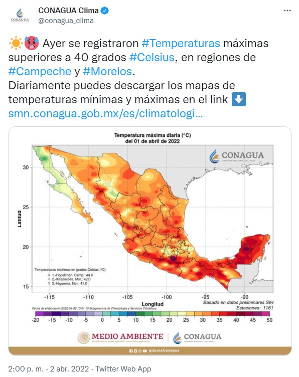
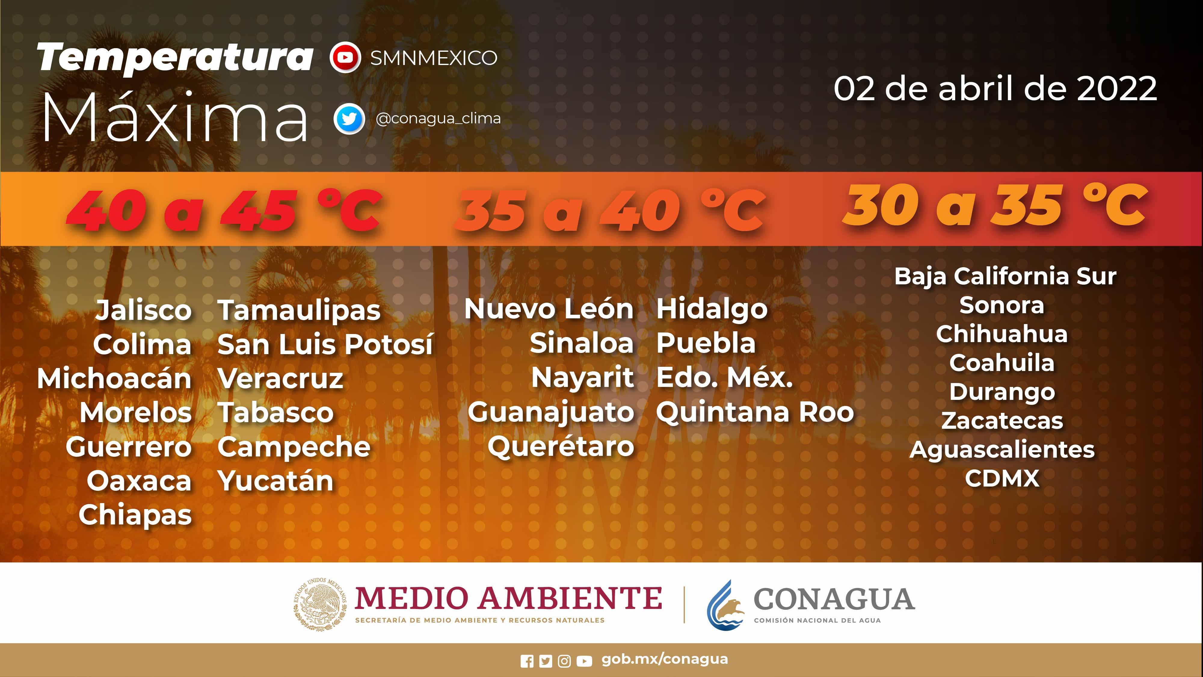
Maximum temperatures of 40 to 45 °C: Michoacan, Guerrero, Morelos, Oaxaca, Veracruz, Campeche and Yucatan.
Maximum temperatures of 35 to 40 °C: Sinaloa, Nayarit, Jalisco, Colima, Nuevo León, Tamaulipas, San Luis Potosi, Hidalgo (north), Queretaro (north), Guanajuato, State of Mexico (southwest), Puebla (north and southwest), Chiapas, Tabasco and Quintana Roo.
PUBLICIDAD
Maximum temperatures from 30 to 35 °C: Baja California Sur, Sonora, Chihuahua, Coahuila, Durango, Zacatecas, Aguascalientes and Mexico City.
While the minimum temperatures for early Sunday are:
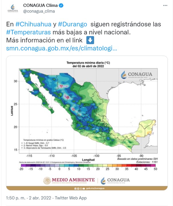
Minimum temperatures from -10 to -5 °C: mountainous areas of Chihuahua and Durango.
Minimum temperatures from -5 to 0 °C: mountainous areas of Sonora, Zacatecas and the State of Mexico.
PUBLICIDAD
Minimum temperatures from 0 to 5 °C: mountainous areas of Baja California, Coahuila, Nuevo Leon, San Luis Potosí, Aguascalientes, Jalisco, Michoacán, Guanajuato, Hidalgo, Puebla and Tlaxcala.
Frosts for early Sunday: Baja California, Sonora, Chihuahua, Durango and Zacatecas.
The National Meteorological Service also announced that during this period the 40th cold front will extend over northern Mexico, in interaction with a low-pressure channel extending over the Mesa del Norte and the Central Mesa, with the subtropical jet stream.
PUBLICIDAD
The agency indicated that this will cause scattered rains and showers accompanied by electric shocks in the northeast and east of the Republic, with possible hail falling mainly in Coahuila, Nuevo León, Tamaulipas and San Luis Potosí, as well as strong gusts of wind on entities of the Mesa del North.
Meanwhile, the ingress of moisture from the Pacific Ocean, the Gulf of Mexico and the Caribbean Sea will cause rains with isolated showers in the southeast of the country and the Yucatan Peninsula:
PUBLICIDAD
Shower intervals: Coahuila, Nuevo Leon, Tamaulipas, San Luis Potosi, Puebla, Veracruz, Tabasco and Chiapas.
Isolated rains: Hidalgo, Tlaxcala, Campeche and Quintana Roo.
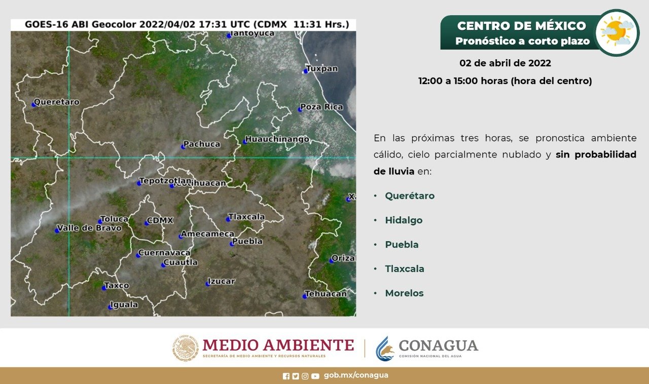
The National Weather Service detailed that this Saturday is forecast in the Valley of Mexico a medium-cloudy sky in the afternoon, as well as a warm to hot environment and with isolated rains in Mexico City and the State of Mexico. In addition to southern component wind from 10 to 20 kilometers per hour with gusts of 40 km/h.
PUBLICIDAD
In the capital of the country, a minimum temperature of 11 to 13° C and a maximum of 30 to 32° C is forecast; for the capital of the State of Mexico, a minimum temperature of 3 to 5° C and a maximum of 25 to 27° C is expected.
In the Gulf of Mexico, a half-cloudy sky is expected with the possibility of showers in Tamaulipas and Veracruz, as well as isolated rains in Tabasco and possible hail fall in Tamaulipas.
PUBLICIDAD
While in the northern table: cloudy skies and showers in Nuevo León and San Luis Potosí, as well as isolated rains in Coahuila with electric shocks. A warm to warm atmosphere is expected in Chihuahua, Durango and Zacatecas.
Central table: partly cloudy sky with showers in Puebla and isolated rains in Hidalgo and Tlaxcala; wind with gusts up to 50km/h in Guanajuato, Querétaro and Puebla.
PUBLICIDAD
KEEP READING:
PUBLICIDAD
PUBLICIDAD
Últimas Noticias
Debanhi Escobar: they secured the motel where she was found lifeless in a cistern
Members of the Specialized Prosecutor's Office in Nuevo León secured the Nueva Castilla Motel as part of the investigations into the case

The oldest person in the world died at the age of 119
Kane Tanaka lived in Japan. She was born six months earlier than George Orwell, the same year that the Wright brothers first flew, and Marie Curie became the first woman to win a Nobel Prize

Macabre find in CDMX: they left a body bagged and tied in a taxi
The body was left in the back seats of the car. It was covered with black bags and tied with industrial tape

The eagles of America will face Manchester City in a duel of legends. Here are the details
The top Mexican football champion will play a match with Pep Guardiola's squad in the Lone Star Cup

Why is it good to bring dogs out to know the world when they are puppies
A so-called protection against the spread of diseases threatens the integral development of dogs


