
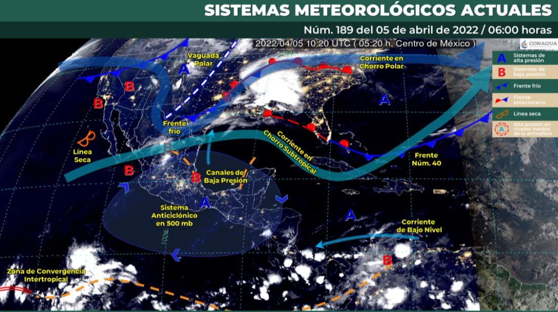
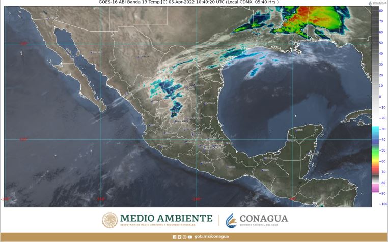
The evening atmosphere will remain hot to very hot in most parts of the country due to the presence of a heat wave, according to the National Weather System. By dawn, it is expected to stay cold. The interaction between a dry line and a subtropical jet stream will generate gusts of strong wind in features in the north and northeast. The probability of rain will remain low (forecast of isolated rainfall in Coahuila, Nuevo Leon, Tamaulipas, Oaxaca and Chiapas).
Mexico will record minimum temperatures of up to -10º C in mountainous areas of Chihuahua and Durango, and up to -5º C in Sonora, Zacatecas and the State of Mexico. In contrast, the highs will go up to 45°C in San Luis Potosi and Veracruz, and up to 40°C in Tamaulipas, Querétaro, Hidalgo, Puebla, Michoacán, Morelos, Guerrero, Oaxaca, Veracruz, Tabasco, Campeche and Yucatan
Valley of Mexico: Partly cloudy sky during the day, no rain in Mexico City and the State of Mexico. South component wind from 10 to 20 km/h with gusts up to 40 km/h. In Mexico City a minimum temperature of 12 to 14° C and a maximum of 29 to 31° C. For the capital of the State of Mexico, a minimum temperature of 4 to 6° C and a maximum of 23 to 25° C.
Baja California Peninsula: Clear skies most of the day, with banks of fog on the west coast of the region and no rain. Cold environment with frost during the morning in the mountains of Baja California and cool environment in the rest of the region. A warm atmosphere is expected during the afternoon. North and northwest wind between 20 and 35 km/h.
North Pacific: Sky with scattered clouds and no rain in the region. Cold to cool morning atmosphere with frost over Sonora mountains. In the afternoon, warm to warm atmosphere. South and southwest wind between 10 and 25 km/h.
Central Pacific: Low cloud cover and no rain. Cold morning atmosphere in high areas, in the afternoon warm to very hot environment. West component wind from 15 to 30 km/h with gusts up to 50 km/h in Jalisco.
South Pacific: Partly cloudy afternoon sky with showers and electric shocks in Chiapas, as well as isolated rains in Oaxaca. No rain in Guerrero. Cool atmosphere in the morning and warm to very hot in the afternoon. Wind from the south component (surada) with gusts of 60 to 70 km/h on the Isthmus of Tehuantepec.
Gulf of Mexico: Partly cloudy sky and increased cloudiness in the afternoon with isolated rains in Tamaulipas. No rain in Veracruz and Tabasco. Cool to mild environment in the morning. During the afternoon very hot and extremely hot atmosphere in the north of Veracruz. South (surada) wind with gusts of 60 to 70 km/h in VeraCruz and 50 to 60 km/h in Tabasco.
Yucatan Peninsula: Clear sky in the morning and mostly cloudy in the afternoon, with no rain in the region. Warm morning atmosphere and in the afternoon warm to very hot. South (surada) wind with gusts up to 50 to 60 km/h in Campeche, Yucatan and Quintana Roo.
Mesa del Norte: Partly cloudy sky with isolated rains in Coahuila and Nuevo León (north). No rain in the rest of the region. Cold morning environment with frost in the mountains of Chihuahua, Durango and Zacatecas. In the afternoon warm to hot and extremely hot atmosphere in eastern San Luis Potosí. Variable direction wind with gusts 60 to 70 km/h and hoppers in Chihuahua, as well as 50 to 60 km/h in Coahuila, Nuevo León, San Luis Potosí, Zacatecas and Durango.
Central Table: Clear skies in the morning and cloudy in the afternoon. No rain in the region. Cool to cold morning atmosphere in mountain areas, in the afternoon, warm to hot environment. Variable wind direction from 20 to 30 km/h and gusts up to 50 km/h in the region.
KEEP READING:
Últimas Noticias
Debanhi Escobar: they secured the motel where she was found lifeless in a cistern
Members of the Specialized Prosecutor's Office in Nuevo León secured the Nueva Castilla Motel as part of the investigations into the case

The oldest person in the world died at the age of 119
Kane Tanaka lived in Japan. She was born six months earlier than George Orwell, the same year that the Wright brothers first flew, and Marie Curie became the first woman to win a Nobel Prize

Macabre find in CDMX: they left a body bagged and tied in a taxi
The body was left in the back seats of the car. It was covered with black bags and tied with industrial tape

The eagles of America will face Manchester City in a duel of legends. Here are the details
The top Mexican football champion will play a match with Pep Guardiola's squad in the Lone Star Cup

Why is it good to bring dogs out to know the world when they are puppies
A so-called protection against the spread of diseases threatens the integral development of dogs


