After last Friday, March 11, a collapse destroyed a lane between kilometers 68 and 69 of the Medellín-Bogotá highway, on the Caño Alegre sector of San Luis, the National Institute of Roads (Invías) reported on Monday that, following the emergency, the passage to a lane on the road will be maintained.
According to the territorial director of Invías in Antioquia, Mauricio Hoyos, due to the instability of the land where the emergency occurred, the removal of debris in the sector and the recovery of the road have been delayed, which is why only one lane has been set up so far.
PUBLICIDAD
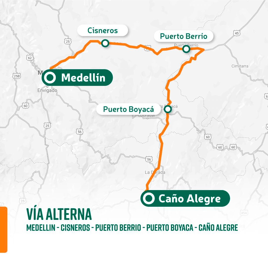
The National Highway Institute also detailed that, at the moment, the passage to a lane enabled on the Medellín-Bogotá highway is between kilometers 68, 69 and 72 of that road. Likewise, the agency reported that travelers who normally travel along this road corridor, can move along the alternative route of Caño Alegre - Puerto Berrio - Cisneros - Medellín.
Here is the map of the alternate route:
The territorial director of Invías in Antioquia also assured that, from the road agency, they remain attentive to any eventuality or emergency that may arise in the sector “to ensure that the passability of people in these sectors is maintained,” Hoyos pointed out.
PUBLICIDAD
It should be noted that, according to the latest hydrometeorological alert published by the Administrative Department of Risk Management of Antioquia (Dagran), there are 17 municipalities in the department that are on red alert for landslide risk.
According to the report, the municipalities on alert are: Murindó, Amalfi, Uramita, Concepción, El Peñol, El Santuario, Granada, Nariño, San Francisco, San Luis, Apartado, Carepa, Chigorodó, Mutatá, Turbo, Barbosa and La Estrella.
PUBLICIDAD
Likewise, the Dagran recommended special attention to the following road corridors that are on alert, in the face of the risk of slippage: Uramita-Dabeiba PR 26+000 Peñas Blancas sector; Dabeiba and Mutatá, and Santuario-Caño Alegre road, km 68 and 84.
Finally, Risk Management also called for maintaining monitoring of 21 other Antioquia municipalities that are on orange alert due to the likelihood of landslides in unstable and high-slope areas.
PUBLICIDAD
According to the alert issued by the Dagran, the 21 municipalities at risk are: Belmira, Entrerríos, Ituango, San Pedro de los Milagros, Buritica, Caicedo, Caicedo, Cañasgordas, Dabeiba, Frontino, Sopetrán, Abejorral, Algeria, El Retiro, La Ceja, Marinilla, Sonson, Andes, Ciudad Bolivar, Montebello, Santa Barbara and Urrao.
It should be remembered that the Medellín-Bogotá highway is not the only road that has had to be closed in recent days due to landslides. On the night of this Monday, March 14, heavy rains that occurred in the metropolitan area of Bucaramanga caused several collapses on the road that connects San Gil with the center of the country.
PUBLICIDAD
According to Blu Radio, after a ravine overflowed over the Curos sector, both the authorities and the Invías decided to close kilometer 66 to kilometer 71 of that road corridor.
“At this time, Santandereans are informed that: the road closure is reported due to landslides, rockfalls, trees, heavy rains and other elements,” Santander Disaster Risk Management reported, through its Twitter account.
PUBLICIDAD
So far, neither Risk Management nor Invías have announced progress in the restoration of traffic in this road corridor.
KEEP READING
PUBLICIDAD
PUBLICIDAD
Últimas Noticias
Debanhi Escobar: they secured the motel where she was found lifeless in a cistern
Members of the Specialized Prosecutor's Office in Nuevo León secured the Nueva Castilla Motel as part of the investigations into the case

The oldest person in the world died at the age of 119
Kane Tanaka lived in Japan. She was born six months earlier than George Orwell, the same year that the Wright brothers first flew, and Marie Curie became the first woman to win a Nobel Prize

Macabre find in CDMX: they left a body bagged and tied in a taxi
The body was left in the back seats of the car. It was covered with black bags and tied with industrial tape

The eagles of America will face Manchester City in a duel of legends. Here are the details
The top Mexican football champion will play a match with Pep Guardiola's squad in the Lone Star Cup

Why is it good to bring dogs out to know the world when they are puppies
A so-called protection against the spread of diseases threatens the integral development of dogs